
El Niño is a pattern most people only think about when a meteorologist mentions it in passing during a forecast, usually in the same breath as “above-average temperatures” or “drier than normal conditions for parts of the Southwest.” It sounds technical, abstract, far away. Something that happens in the Pacific and maybe shows up as a strange winter or a bad wildfire season, if it shows up at all. But what is building in the tropical Pacific Ocean right now is not background noise. It is a force with a documented track record of reshaping monsoons in India, cracking soil in East Africa, thickening smoke over the Amazon, and deciding whether the Gulf Coast gets a brutal winter or a wet one. And the conditions already in place make this particular moment unlike any that has come before it.
El Niño is emerging faster than expected, and the odds are increasing that it could become historically strong, a rare “Super” El Niño, by fall or winter. That phrase gets tossed around a lot on weather apps and social media in ways that drain it of meaning. But there is a specific technical threshold behind it, and what happens when that threshold is crossed is genuinely different in scale and consequence from a run-of-the-mill warm Pacific year. Scientists are paying attention, climate agencies are revising their probability estimates upward week by week, and the forecasting community is not hiding uncertainty here.
The reason this one is different is not just the Pacific Ocean. The Pacific has warmed before. What has changed is the world it is warming into: a planet that has already absorbed more than a degree and a half of human-caused heating, where the baseline was already breaking records before El Niño added a single decimal point. What is building in that equatorial water is a force multiplier, and its effects are going to register in grocery bills, wildfire seasons, flood maps, and the temperature outside your door whether or not you ever look up what Niño 3.4 means.
What a Super El Niño Actually Is
El Niño is a natural climate cycle that happens when the tropical Pacific Ocean warms enough to reorganize wind patterns throughout the atmosphere, triggering a ripple effect on weather conditions worldwide. The cycle swings between warm and cool phases, El Niño and La Niña, on an irregular schedule of roughly two to seven years, and in most years the warming is modest enough that its effects blend into the general noise of weather variation.
Weak El Niño conditions develop once the temperature in the monitoring region rises over 0.5 degrees Celsius above average for an extended period. Water temperatures must climb more than 2 degrees above average for the event to qualify as very strong or “Super.” That extra degree and a half between “weak” and “super” sounds small. It is not. At that upper threshold, the volume of heat transferred from ocean to atmosphere is sufficient to physically displace jet streams in both hemispheres, pulling global weather patterns into configurations they would not otherwise reach. The effects are not just bigger; they are categorically different.
There are only three confirmed super El Niños on record: in 1982-83, 1997-98, and 2015-16. Each one left a long tail of consequences. All three drove dramatic changes in regional ocean temperatures, leading to unprecedented marine heat waves that destroyed or damaged coral reefs and caused mass die-offs and starvation among many marine organisms, from starfish to seabirds and marine mammals. Each one also reshuffled rainfall and drought patterns in ways that affected agriculture, water supply, and fire seasons for years afterward.
The Numbers Coming Out of NOAA Right Now
NOAA’s Climate Prediction Center has issued an El Niño Watch, with El Niño now likely to emerge soon, an 82% chance during the May-July 2026 window, and continue through Northern Hemisphere winter 2026-27, with a 96% probability through December through February. A 96% probability of an event persisting through winter is, as meteorologists put it, a near lock.
NOAA’s previous April advisory had placed a 61% probability on El Niño forming between May and July, with a 1-in-4 chance of a very strong event. Both figures have since been revised upward based on a growing pool of warm water building in the depths of the central and eastern equatorial Pacific, which forecasters expect to rise to the surface and fuel El Niño’s development. The pace at which these estimates are climbing is itself significant. In most developing El Niño events, the models converge slowly and cautiously. What is happening now is the opposite.
Michelle L’Heureux, a physical scientist at NOAA’s Climate Prediction Center, put it plainly in an ABC News report: “There is a 2-in-3 chance of a ‘strong’ or ‘very strong’ El Niño during the November 2026 to January 2027 season,” while acknowledging there remains a 1-in-3 chance of an event weaker than that. Scientists are being careful not to overstate what remains genuinely uncertain. But a 2-in-3 probability of a strong or very strong event is not uncertainty that resolves quietly. NOAA also noted that stronger El Niño events can only make certain impacts more likely; they do not guarantee strong impacts in every region. That caveat matters, and it is worth holding. Predictions based on a handful of historical super El Niños carry real statistical limits.
Why This One Is Different From Every Previous Event
The effects of El Niño will “be amplified considerably by the now nearly 1.5°C of global warming experienced as of 2026,” according to Daniel Swain, a climate scientist at the University of California, Los Angeles. “In modern human history,” he said, “we’ve never experienced a strong or very strong El Niño event amid pre-existing conditions that were this warm globally.”
That framing is important. Every previous super El Niño unfolded against a cooler baseline. The 1997-98 event, which remains the most destructive El Niño in modern memory by most measures, occurred in a world roughly 0.5 degrees Celsius cooler than the one we are in now. A previous El Niño helped drive average global temperatures in 2024 to a record 1.55 degrees Celsius above preindustrial levels. The world that produced that record is the world today’s El Niño is building on top of.
A more likely near-term impact is global heat: El Niño is loading the dice toward 2026 or 2027 becoming Earth’s warmest year on record. NOAA has already called it “very likely” that 2026 will be one of the five warmest on record, and that assessment does not yet account for El Niño’s warming contribution. The climate system is being asked to absorb two warming forces at once: the long-term human-caused trend and the short-term ocean heat dump that El Niño delivers. During an extreme El Niño event, an additional 0.2°C can be added to the average global temperature on top of already elevated readings from warming, which means global average temperatures could potentially exceed 1.7°C above pre-industrial levels this year.
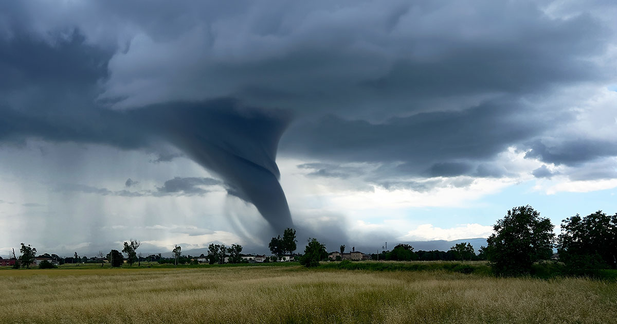
Fire, Flood, and the Regions Most at Risk
Droughts and heat waves can flourish in some regions under El Niño, fueling wildfire danger and water supply concerns, while others are swamped by flooding rainfall. The geography of who gets what is not random; certain regions have consistent El Niño signatures that repeat across events. But the intensity and duration of those effects is harder to predict, and this year’s elevated baseline makes the historical playbook less reliable than it used to be.
The wildfire picture is one of the more alarming dimensions of what is coming. A super El Niño “against the backdrop of elevated baseline temperatures could increase the risk of widespread or unusually intense fires in normally damp regions where such fires are not common,” Swain has warned, pointing specifically to the Amazon and parts of Oceania, where peatlands “can burn for months on end.” Peatland fires are not like forest fires. They smolder underground and release enormous quantities of carbon into the atmosphere long after surface flames are extinguished.
The United States is already in a precarious position heading into this event. Drought in the continental United States has expanded to its record-highest level for spring, with varying levels of drought covering 62.78% of the country as of late April, the worst of it centered on much of the South, West, and Plains. Dryness in the Lower 48 states has not been this expansive in spring in the entire history of the U.S. Drought Monitor, which holds data back to 2000. El Niño arriving into already parched conditions is not the same as El Niño arriving into normal spring moisture. The soil has no reserve. The vegetation is already dry.
Globally, the numbers are stark even before El Niño’s peak arrives. Record-breaking heat and drought have fueled the world’s worst ever start to a wildfire year, with more than 150 million hectares burned in just the first four months of 2026, according to satellite estimates from the Global Wildfire Information System, a joint initiative of the GEO and Copernicus programs. That is an area nearly the size of Alaska and roughly double the seasonal average for this period.
When the Event Fades, the Damage May Not
The dimension of the developing El Niño that climate scientists find most disturbing is not necessarily what happens during the event. It is what happens after.
A December 2025 study published in Nature Communications found that abrupt and persistent transitions between stable states in the climate system, what researchers call climate regime transitions, pose serious threats to ecosystems and human well-being, and that the likelihood of these transitions increases substantially during super El Niño events due to their remarkable climate perturbations. In plain terms: the climate in some regions does not simply snap back to where it was before the event. It arrives somewhere new, and it stays there.
Analyzing all three super El Niños on record alongside climate model projections, the researchers found that events of this intensity increase the likelihood of these abrupt, lasting changes in temperature, sea surface conditions, and soil moisture that can endure for years or even decades. The researchers also concluded that this destabilizing effect on climate states will be greatly amplified under future greenhouse warming, with the central North Pacific, the Gulf of Mexico, East Africa, the Amazon, central Australia, and the Maritime Continent around Indonesia likely to be worst affected.
The implication is that the effects of a 2026 super El Niño may not simply reverse when Pacific temperatures cool again; some changes could lock in. One specific historical example: after the 2015-16 super El Niño, the Gulf of Mexico reached a new sustained level of warmth that may have contributed to stronger hurricanes along the Gulf Coast in the following years. That is what a lasting climate transition looks like in practice: not a dramatic collapse, but a floor that quietly rises and does not come back down.
The Honest Limits of What Anyone Can Know Right Now
There is a version of El Niño coverage that converts probability into certainty, and it is worth resisting. With only three super El Niños on record, the foundations of predictions about what this one will do are shaky at best. “Scientists who are basing their conclusions on what is likely to happen this time, based on a small sample of past events, should not have as much confidence,” warned Paul Roundy, professor of atmospheric science at the University at Albany, noting the uncertainty about whether we are heading for supercharged global warming for the next decade or an enhanced period of just a year or so.
The World Meteorological Organization echoed that caution in its latest Global Seasonal Climate Outlook, saying “a key source of uncertainty is related to the potential intensity and duration of the El Niño event,” and acknowledging that “while some model forecasts indicate the possibility of stronger conditions later in the year, there is currently no consensus or sufficient confidence to confirm or exclude a high-intensity event.” The forecasting community is not hiding uncertainty here. They are flagging it clearly. What they are not doing is pretending the signal is not real.
While forecasters are more confident in El Niño forming, “there is still substantial uncertainty in the peak strength of El Niño,” the Climate Prediction Center has stated. The odds of a Super El Niño between November and January have increased from a 1-in-4 chance last month to about a 1-in-3 chance in the latest strength probabilities. Those numbers will continue to change. The models will be updated as the ocean-atmosphere coupling either syncs up or fails to through the summer months.
What This Means for You
The question of how to hold a statistic like “82% probability of El Niño by July” in a normal, practical life is a real one. It does not translate into a specific action on a specific Thursday. It does translate into paying more attention than usual to a few things.
Food prices are one of them. El Niño’s disruption of rainfall and heat patterns in agricultural regions has a documented track record of pushing up commodity prices, grain, coffee, cocoa, palm oil, sometimes sharply and sometimes with a several-month lag. Research shows that El Niño events have been linked to crop failures, increased wildfire risk, increased flood risk, heightened concurrent drought frequency, disruptions to fisheries, and higher disease risk in various regions of the world. Those links run eventually through grocery shelves.
Fire season preparedness is another. If you live in the western United States, the Southern Plains, the Southeast, or anywhere that was already dry heading into spring, the combination of record drought and an intensifying El Niño makes the period from now through late summer worth paying attention to. Climate scientist Swain has stated plainly that “it would not be surprising to see some unprecedented global impacts by later in 2026 into 2027 in terms of flood, drought, and wildfire-related extremes,” and that “either 2026 or 2027, or both, stand a good chance of setting a new global temperature record, yet again.”
And then there is the longer arc. The regime-transition research suggests that even when El Niño itself is over, the world it leaves behind may be measurably different from the one it found. Some of those changes will be incremental and hard to notice. Some will not be.
What We’re Actually Watching
The fact that scientists are being careful with their language right now is not a sign that things might be fine. Careful language is what science looks like when the evidence is strong enough to take seriously but the sample size is small enough to stay honest. Both things are true here.
As Wilfran Moufouma Okia, Chief of Climate Prediction at the World Meteorological Organization, put it: “After a period of neutral conditions at the start of the year, climate models are now strongly aligned, and there is high confidence in the onset of El Niño, followed by further intensification in the months that follow.” That is a measured sentence from a careful organization, and it does not contain any ambiguity about direction.
What makes this moment genuinely new is not the El Niño itself. Natural climate cycles have been running their course for as long as the ocean has had weather. What is new is the world it is arriving into: one where the atmosphere is warmer, the soil in large parts of the country is already at record dryness, the wildfire season has already had its worst start on record, and the buffer between “bad year” and “unprecedented year” has been eaten away by a decade and a half of rising baselines. The machinery is the same. The conditions it is operating in are not.
The Signal Is Real
You do not need to follow the Niño 3.4 monitoring region on a daily basis to feel what is coming. But it is worth knowing that this is not a weather story. It is a compounding story: an already-hot planet, record drought in the ground, a wildfire season off to its worst start in history, and now a major Pacific warming event arriving faster than forecasters expected just two months ago.
The scientists most closely watching this are being honest about what they do not know, and that honesty is worth taking seriously. They are not certain this will be a record-breaking super El Niño. They are not certain which regions will bear the worst of it or for how long. What they are saying, clearly and in measurable terms, is that the direction of this is not in question, only the magnitude. And magnitude, in this case, is the difference between a bad year and one that leaves a permanent mark on the systems we all depend on, from food supplies to coastlines to the dry hillsides behind towns that have never burned before.
You do not need to do anything differently on the strength of a weather forecast. But if the summer turns unusually hot, the fires start earlier and burn further, or the winter brings flooding in places that do not expect it, you will know some of the reason why. The ocean has been trying to tell us something. The models are finally saying it out loud.
AI Disclaimer: This article was created with the assistance of AI tools and reviewed by a human editor.