
There is a place that every major civilization seems to have remembered, even when the name changed and the geography shifted. It shows up in Genesis as a lush garden watered by four rivers, a place of abundance that humanity somehow lost. It shows up in Sumerian poetry as a primeval paradise. It shows up in the Quran as a home that was forfeited. Every tradition has its own version of the original place, the first place, the good place before everything went wrong. Humans have been looking for it, arguing about it, and occasionally claiming to have found it for about as long as humans have been writing things down.
For most of that time, the search was confined to old texts and educated guesses. You could cross-reference Genesis descriptions against known geography and get heated about it at a conference. What changed things was the addition of satellites. Starting in the late twentieth century, radar imaging from space began revealing something that no map, no theology, and no centuries of scholarship had previously been able to show: riverbeds. Ancient ones. Invisible from the ground, buried under desert sands that have been dry for thousands of years, but still legible from orbit like pencil marks under paint.
The question of whether those riverbeds are the rivers of Eden is, of course, the part where things get interesting. And also the part where nobody fully agrees.
The Four Rivers Nobody Could Find
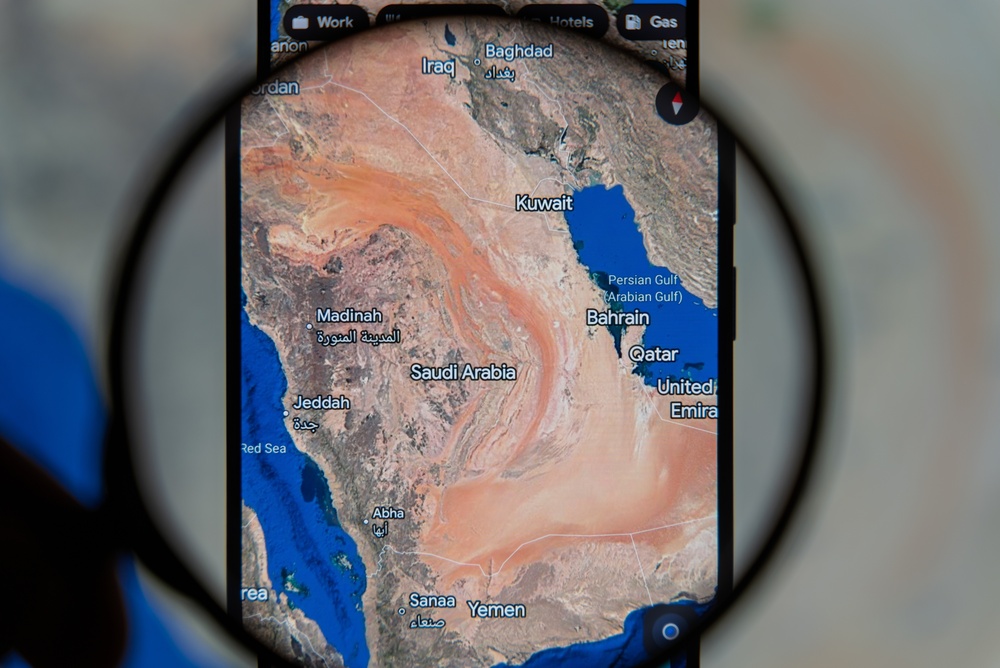
Genesis 2:10 – 14 lists four rivers in association with the Garden of Eden: Pishon, Gihon, Tigris, and Euphrates. Two of those four are easy. The Tigris and Euphrates are easy to plot on a map, played a major role in the development of ancient Mesopotamian society, and still flow today. The Tigris originates in the mountains of eastern Turkey and runs south into Iraq, where it joins the Euphrates before both empty into the Persian Gulf.
The other two, the Pishon and the Gihon, are the problem. While the Tigris and Euphrates remain well-known rivers in modern Iraq, the Pishon and Gihon vanished from human knowledge millennia ago. Scholars have spent centuries trying to figure out what they were and where they went. Genesis explains that the Pishon “flows around the whole land of Havilah, where there is gold,” while the Gihon flows around the land of Cush. Scholars say Havilah was in South Arabia, a region known for precious metals. But Cush’s location is elusive, because the name is used in the Bible for two distinct regions: one in Mesopotamia, and one in Africa, around Nubia. That ambiguity about Cush has sent researchers in two very different directions across the centuries, and both directions are currently occupied.
The River the Shuttle Found
In 1994, Dr. Farouk El-Baz, Director of the Center for Remote Sensing at Boston University, used ground-penetrating radar images from the Space Shuttle to locate and trace the bed of an ancient river that flowed for about 600 miles through Saudi Arabia, ending in Kuwait where it became a broad watercourse three miles wide. The images had been gathered years earlier, during NASA’s Space Shuttle Endeavour missions, but what El-Baz saw in them was something that had been sitting under the Arabian desert the whole time, waiting for the right kind of eyes.
This “Kuwait River,” as El-Baz named it, also known as Wadi al-Batin, is believed to have been flowing until around 2500 to 3000 BC, and has its origins in Medina province in western Saudi Arabia in an area called Mahd adh Dhahab, also known as the Cradle of Gold, which has been the main gold-mining area in the Arabian Peninsula since at least 3000 BC.
That detail about gold is not incidental. Genesis describes the Pishon as the river that “flows around the whole land of Havilah, where there is gold.” The headwaters of the Wadi al-Batin drain the ancient gold and onyx areas of Mahd adh Dhahab and Wadi al Aqiq, and all three commodities mentioned in Genesis are known to have been transported by camel into Mesopotamia at an early date. That is either a striking coincidence or a memory encoded in text, preserved across thousands of years after the river itself dried up and vanished beneath the sand.
The data revealed a fossilized river up to three miles wide, active during a wetter Holocene era before drying between 2000 and 3500 BC due to climate shifts. The Holocene, the geological epoch that began about 12,000 years ago as the last Ice Age ended, was a significantly wetter period across much of the Middle East and Arabia. Rivers ran where today there is only dust.
A Garden Under the Gulf
El-Baz was not the first person to look at this region and think: Eden. Archaeologist Juris Zarins argued that the Garden of Eden was situated at the head of the Persian Gulf, in present-day Kuwait, where the Tigris and Euphrates rivers run into the sea, based on research using information from many different sources including LANDSAT images from space.
In Zarins’ reconstruction, all four rivers – the Pishon, Euphrates, Tigris, and Gihon – once converged near the head of the Persian Gulf to create a fertile land fit for a garden. Around 4000 BCE, Zarins believed, the lush oasis of Eden was submerged beneath the waters of the Gulf as a sudden rise in sea level swallowed prehistoric settlements. The Gihon, in his theory, corresponds not to an African river but to the Karun, an Iranian river that once flowed southwest toward the Gulf. The translators of the King James Bible in the 17th century rendered the Hebrew “Gush” or “Kush” as “Ethiopia,” which sent researchers toward Africa, when the original term may have referred to a Mesopotamian region entirely.
Zarins proposed that the melting glaciers raised sea levels dramatically, flooding a once-lush basin now buried beneath the Persian Gulf. Using satellite radar imaging, he identified riverbeds that once flowed across central and southern Arabia into the Gulf. The problem is that no marine archaeology has supported Zarins’ theory. And there is a textual objection, too: critics argue the Genesis text indicates all rivers flowed from Eden, while Zarins’ model has them flowing into the site, a contradiction highlighted by Joel Baden, Professor of Hebrew Bible at Yale Divinity School.
These are not small objections. But they are also not the kind of objections that tend to stop people who are genuinely convinced they have found something real.
The African Theory
While the Persian Gulf contingent has been arguing its case for decades, a separate line of research points somewhere else entirely. Researcher Mahmood Jawaid has claimed the Biblical garden was in northwest Ethiopia. The chemical engineer based in Texas said that the fertile region of Bahir Dar, near the southern end of Lake Tana and where the Blue Nile begins, is the location based on his careful research.
Jawaid based his research on a careful reading of both the Bible and the Quran, analyzing descriptions of Adam and Eve, the rivers and the garden itself. His 2025 study, which has not been peer-reviewed, noted the Blue Nile could correspond to the Biblical Gihon, and Lake Tana’s outflows divide into multiple waterways, potentially forming the four rivers described in Genesis.
His argument leans heavily on the Gihon’s association with the land of Cush, the same textual problem that haunts the Persian Gulf theory but resolved in the opposite direction. Jawaid emphasizes that the Gihon is said to encircle the land of Cush, a term historically linked to Ethiopia, reinforcing his claim that the Blue Nile is the Gihon. He also makes an environmental case: the Ethiopian Highlands, sitting around 6,000 feet above sea level, are rich in vegetation and wildlife, with a temperate climate and flowing rivers, features that align with scriptural descriptions of Eden as a place of abundance and comfort.
Jawaid also draws a symbolic connection between the volcanic ridges surrounding Lake Tana and the “flaming sword” mentioned in Genesis, which guarded the Tree of Life after Adam and Eve’s expulsion, suggesting these volcanoes could metaphorically represent the fiery barrier described in scripture. It is a creative reading. Whether it is a convincing one depends on how much weight you give to metaphor as evidence, which is itself a question the field has never fully resolved.
What the Arabia Theory Actually Requires You to Believe
Go back to the Wadi al-Batin and the Saudi Arabia case for a moment, because the thing that keeps drawing researchers there is not just the gold. It is the whole package.
Geological and biblical evidence suggests that the four rivers of Eden from west to east were the Pishon (Wadi al-Batin), the Euphrates, the Tigris, and the Gihon (the Karun and/or the Karkheh). The Wadi al-Batin confluences with the Tigris and Euphrates in the land of Mesopotamia, exactly as the Bible states. The geographic alignment is not approximate; it is specific.
What you also have to accept is that someone, writing down or transmitting the story of Eden, remembered a river that had been dry for between one thousand and two thousand years by the time Genesis was committed to text. Environmental data reveals Arabia’s transformation from a lush, river-fed landscape to an arid desert after the last Ice Age. Rising sea levels submerged portions of what may have been Eden’s river delta, erasing physical evidence that only space-based radar could recover.
That is either an extraordinary feat of cultural memory, or it is coincidence dressed up very convincingly. Scholars who take the geographical evidence seriously tend to argue for memory. The river dried up, but the story of the river did not.
The Question That Stays Open
National Geographic’s September 2025 overview of the ongoing search notes that no single consensus exists among researchers, and that the most recent proposals favor Africa and the Middle East while using satellite imagery, ancient texts, and reinterpretations of biblical geography in combination. The search has not converged. If anything, the addition of new tools has produced more competing candidates, not fewer.
That is probably the honest answer to hold onto. A considerable amount of research has been done on matching the rivers in Genesis to real ones, on the premise that the Garden was “obviously a geographic reality” to the writer of the Genesis verse, and thus dismissing the physical placement of the rivers is the contribution of the interpreters. The text itself was written by someone who assumed the reader knew where these places were. The geography was not symbolic to the author. Whether that original geography survived into the versions we have is, at this point, genuinely uncertain.
What the satellite imagery has given us is at least this: evidence that the landscape of that region looked entirely different a few thousand years ago. Rivers ran through Arabia. The Persian Gulf was once a fertile valley. The area around Lake Tana in Ethiopia is genuinely lush in ways that most of the ancient world is not. None of that proves the story. But it does mean the story was not necessarily told in a vacuum, which is something.
The Part Nobody Can Settle
The search for Eden is, at its core, a very human thing to keep doing. There is something in the story that refuses to stay purely symbolic, even for people who would describe themselves as secular. The image of an original good place, abundant and watered and unhurried, is one that something in us keeps reaching for, keeps trying to locate on a map.
The satellite data is real. The dry riverbed is real. The gold deposits at Mahd adh Dhahab are real and old and right where the text said they would be. The Ethiopian Highlands are genuinely beautiful in ways that line up with certain readings of the text. None of it proves anything with finality, and the researchers involved are honest about that. Despite numerous expeditions, no discovery has definitively linked any site to the biblical paradise. Each proposed location offers compelling arguments but lacks the decisive evidence needed for universal acceptance.
What the research does do is put a physical world underneath a very old story. Whether that world was Eden, or whether Eden was a story about that world, may not be a question that archaeology or remote sensing can fully answer. The rivers were real. The landscape was real. The memory that someone thought it was worth recording, that there had once been a place where everything was as it should be, that is probably the most durable thing of all.
AI Disclaimer: This article was created with the assistance of AI tools and reviewed by a human editor.